Current Field Projects
Current projects (construction of the project itself may be complete but analysis of archaeological resources is ongoing):
- Steven’s Stadium Entrance Upgrade (American Period Refuse, Mission Zanja (canal) (add hotlink)
- Alviso Mall (American Period infrastructure, ruins of 4th and 5th Mission Santa Clara churches; Mission Rancheria)
- Alviso Street Parking Garage and Edward M. Dowd Art and Art History Building (American Period occupation, Mission Rancheria) (add hotlink)
- Charney School of Law (American Period residential occupation, 3rd Mission Quadrangle) (add hotlink)
Edward M. Dowd Art and Art History Groundbreaking
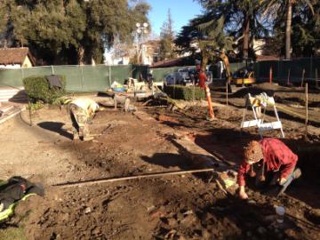
The groundbreaking ceremony for the new Edward M. Dowd Art & Art History Building marked a first for CRM; we were invited to exhibit our findings excavated from beneath the building location. The entire area surrounding the new building had been the subject of an intense, three year archaeological project resulting in the recovery of hundreds of thousands of mission era artifacts dating from about 1780 to the early 1800’s. The building site sits atop a portion of the former Mission Santa Clara Native American village (Ranchería). In addition to artifacts of daily living, we encountered the remains of at least four residential adobe structures, one of which is commemorated in the pavement within the new parking structure on its precise former location.
The artifact table was a resounding success; nearly everyone stopped by and engaged us in conversation and asked many great questions. Santa Clara Mayor Jamie Matthews was very appreciative of the CRM process and gave us a great “shout out” during his dedication speech. Exhibits for these finds are currently being planned in conjunction with the de Saisset Museum and University Archives and are currently slated for installation in the Fall of 2017.
Stevens Stadium Renovation
The Cultural Resource Management Program continues to be very busy about campus! A large part of this spring was spent mitigating archaeological features encountered during the construction of the new Stevens Stadium entrance. The most exciting find was a portion of the Mission Santa Clara acequia madre (literally, mother ditch) for the irrigation of the orchard and crop fields. Acequias had been widely used throughout Spain since the time of the Moorish conquest, and the early Spanish colonists brought with them sophisticated knowledge of how to construct large-scale irrigation systems. This acequia was filled in with hundreds of pounds of hand-molded roof tile wasters (rejected over/under fired bricks).
It is highly unlikely that the canal would have been allowed to silt in or be used as a dumping ground while still in use. The building of acequias, or irrigation canals, was an important element in Spanish efforts to colonize California. California was, and is, semiarid, and irrigation was vitally necessary for the success of agriculture. Because of the discarded bricks, we postulate that there was a post-mission (Mexican Colonial period) tile firing kiln nearby that used the old ditch depression as a dumping ground. It is known that adobe structures continued to be built in Santa Clara until well into the 1840s.
Mission Santa Clara’s acequia madre, which dates to the late 1700s, was originally hand dug from a large spring (later named Cook’s Pond) formerly located in and around the southeast part of campus (under the Operations Building) Historic maps show this ditch running roughly north up to the area near Franklin Street, where the third reiteration of the mission was located. It continued north, feeding the crop fields, before merging with a creek that drained into the Guadalupe River. In addition to the acequia itself, at least two smaller, feeder ditches that branched off the acequia into the mission orchard (formerly located in and around Buck Shaw Field and across what is now the El Camino Real) were encountered during the stadium renovation. This marks the first time that a portion of the mission irrigation system has ever been found, so we now have a segment that we can “ground truth” to our maps with GPS.
Alviso Mall
While you may have walked down the Alviso Mall many times since its installation last year, you may not have realized what was underneath your feet as you did so. During construction last summer, archaeologists mitigated several archaeological features, including two of Mission Santa Clara’s previous five churches!
Mission Santa Clara moved five times during its existence (the current church we know today is the sixth, rebuilt upon the fifth location after a fire in 1926). The third Mission Santa Clara complex (on what is now Franklin Street) was abandoned in 1818, when the Mission Church suffered severe damage in an earthquake. Fray José Viader and Fray Magín Catalá, who served at Santa Clara from the 1790s to the1830s, built a temporary adobe church near the present site of Kenna Hall on the University campus. This building was used as the church between 1819 and 1825 and as the Indian boys’ residence between 1825 and 1836. After secularization, the building eventually became a dance hall. It was purchased by the college in 1860 and razed in 1867.
During the demolition of the Alviso streetscape in 2014, archaeologists encountered a section of the foundation of this fourth church. A piece of its north wall had been encountered in 1995 during a previous campus project, however, the recent discovery of the west wall now gives us a better understanding of the size and orientation of this building. Like all adobe buildings, the foundation consisted of 3-4’ wide trenches filled with large stones, then gravel, upon which the adobe walls were laid. It is this alignment of large cobbles covered with adobe “melt” that was encountered during construction (Figure 1). A small piece of the wall had to be removed to accommodate the new landscaping; however, it remains largely intact under the Kenna lawn.
This project also uncovered the original cobble foundations of the 1825 church and later brick footings from the Italianate façade constructed over the front of the church in the 1860s. The lower right corner of Figure 2 shows a section of the large cobbles still in place. The rest of this rock alignment lies underneath brick rubble from the post-fire demolition, which was not removed for this project.
Along the west side of Alviso, in the area between Donohoe and St. Joseph’s Hall, we encountered segments of the old 19th century wooden sidewalk that ran the length of the street (Figure 3). Along the northern portion of the project area, near Alumni Science, we encountered mission-era deposits associated with the Native American rancheria (village) at Mission Santa Clara. These deposits date from approximately 1800. Aside from minor impacts, they remain intact beneath the cobble walkway.
So what’s the lesson here? Despite endless 19th, 20th and 21st century impacts literally punching holes throughout the local archaeological landscape, there are still pockets of intact history that exist and can be seen, studied and often preserved. Never assume it’s all gone!
Franklin Street History
Perhaps no street within the city of Santa Clara is more important than Franklin Street. As part of the original city grid laid out in 1847, it has not changed location in over 150 years. Shops, businesses, a trolley system, and residences depended on this roadway, and the town of Santa Clara literally grew up around it. It is still a critical transportation corridor today.
Among the waves of people arriving in Santa Clara during the 1850s, were many immigrants who were originally from Germany. Most came from the Electorate of Hessen, consisting of members of the German confederation such as the Grand Duchy of Baden, the Kingdom of Württemberg and the Kingdom of Bavaria. Others left their homeland later and immigrated to the United States because of unrest in the German states.
Like much of Europe during the 19th century, Germany was not a cohesive country. War, starvation, industrialization, ethnic strife, and religious differences created a fluid nation with massive movements in population, rapidly changing alliances, and shifting borders. Varying combinations of these factors led to a massive migration of German speaking peoples to the New World in search of a better life.
From the late 1860s through the 1880s, numerous German immigrants would settle in and around Santa Clara. Eventually those with German backgrounds would make up 20% of the town's population. Here, they created a cohesive German community and would become economically and socially involved in town life. Immigrants, attracted by the growing employment opportunities, were so numerous that the neighborhood east of Lafayette, north of Santa Clara College, and south of Harrison Street became known as the German Colony.
More and more people were attracted to the region as agricultural production expanded and manufacturing enterprises grew during the first decade of the 20th century. Santa Clara had 3,650 residents in 1900, 4,000 by 1902, and 5,000 by the end of the first decade. Santa Clara's growth in population included a simultaneous rise in the number of immigrants from Spain, Portugal, and Italy; emigrating from troubled areas of Europe at the end of the 19th century. Italian immigrants came to Santa Clara from all regions of Italy, including Sicily, Calabria, Basilicata, Tuscany, and Piedmont. Beginning in the 1880s, these immigrants worked as farmers, ranchers, orchardists, vegetable growers, and winemakers.
The earliest Italian immigrants began to settle in originally German neighborhoods east of Lafayette Street. Here, they resided and established small individual businesses, e.g., candy stores, barber shops, and shoe repair shops. While many would find work in the canneries and the orchards, others were employed at the Eberhard Tannery and Pacific Manufacturing Company. By the 1920s they would supplant most of the previous German population. Later this area of Santa Clara would be known as "Little Italy".
The large businesses established by early German immigrants would be a major source of employment for the later arrivals. Immigrants to Santa Clara found work in the nearby tannery and the brewery along with the nearby Enterprise Mill and Lumber Company (later called the Pacific Manufacturing Company), which was located on the corner of Bellomy, Union (Park) Avenue and The Alameda.
Other German businesses in the neighborhood included bakeries, a beer bottling plant, saloons, a paint shop, pharmacies, and other businesses essential to the daily lives of the local inhabitants. Santa Clara’s German neighborhood also had facilities for social gathering.
The site on which the Edward M. Dowd Art and Art History Building sits was once a thriving community of immigrant families with strong work ethics, dreams of better lives, and the determination to make them happen. Santa Clara’s origins are that of a “blue collar” town. Marty Boland, a longtime resident of Santa Clara, summed up the nature of the area during the American Period when he stated “the town lived by [the factory] whistle”. The American Period artifacts exhibited here are representative of individual households from this historic, once-thriving community.